In the clinical environment, we are trained to act on data. We trust monitors, laboratory values, and imaging because we understand where the data comes from and, just as importantly, where they fail. In the mountains, that rigor is often abandoned. Even experienced clinicians routinely make consequential decisions based on a single weather app displaying a simplified icon for the nearest town. In alpine and remote environments, this shortcut can be dangerous.
In wilderness medicine, weather is not a background context; it is the dominant environmental vital sign. It dictates mechanisms of injury, physiological stress, and whether evacuation is possible at all. Misinterpreting weather data does not merely cause discomfort; it can close rescue windows and convert minor injuries into fatal exposure events. Understanding why weather apps disagree, and which tools are appropriate for wilderness decision-making, requires understanding where their data comes from and how it should be interpreted.
Forecasts as Diagnostic Tests
Weather forecasts should be interpreted the same way clinicians interpret diagnostic tests: in terms of sensitivity, specificity, and resolution. A forecast is not a fact; it is a probabilistic model output with known limitations.
Consumer weather apps present deterministic summaries, such as "sunny," "5°C/41°F," "light winds,” that obscure uncertainty. For wilderness clinicians, this is analogous to treating a single vital sign as definitive while ignoring trend data or clinical context. In complex terrain, oversimplified forecasts provide false reassurance precisely when uncertainty should drive more conservative decision-making.
Where Weather App Data Comes From: Models and Resolution
Most weather apps draw from a small number of global numerical weather prediction models, primarily the U.S. Global Forecast System (GFS) and the European Centre for Medium-Range Weather Forecasts (ECMWF). The GFS operates at a spatial resolution of roughly 28 km (18 miles), while ECMWF offers higher resolution at approximately 9 km (6 miles). In flat terrain, these models perform well. In mountainous regions, they do not.
Each model grid cell averages terrain elevation within that cell. In complex topography, this creates a smoothing artifact: valleys and summits are mathematically flattened into a single representative altitude (Figure 1). If a model assumes terrain at 1,500 meters (~5,000 feet) while a patient or rescuer is at 3,000 meters (~10,000 feet), temperature, wind speed, and precipitation phase can be dramatically misrepresented. Wind acceleration around ridges and cols, critical for exposure risk and aviation operations, is particularly underestimated.
These limitations are not failures of the models; they are intrinsic to resolution constraints. The problem arises when apps fail to communicate those constraints to the user.
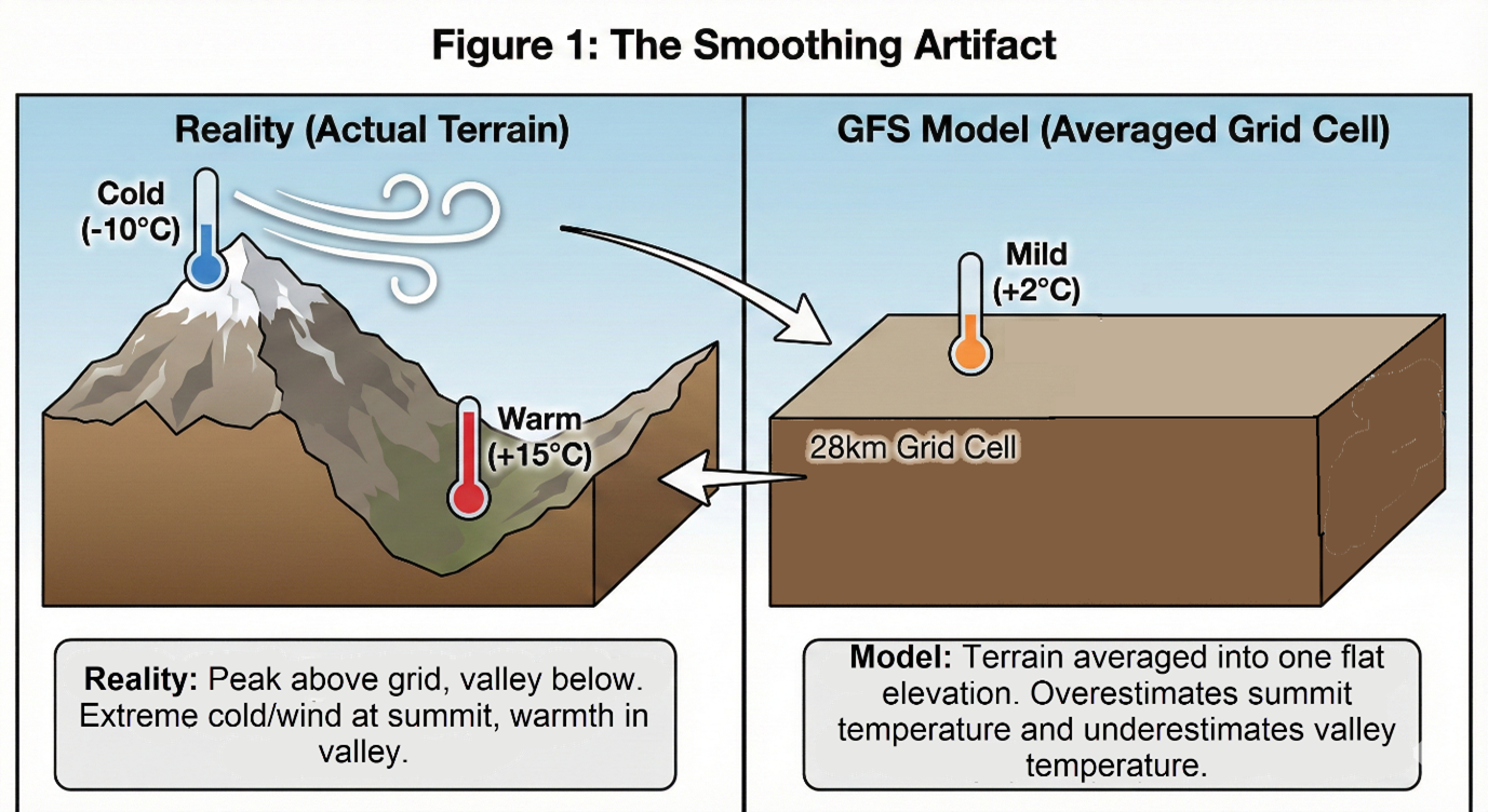
The Smoothing Artifact. A visual representation of how model terrain averaging leads to predictable error: the model overestimates temperatures at the summit and underestimates them in the valley. [Image generated by Gemini Nano Banana Pro; edited by author for accuracy]
Aggregation, Smoothing, and Mountain Microclimates
Consumer weather apps function as aggregators. They ingest model output, apply smoothing algorithms, and present a simplified interface optimized for urban users. The forecast location is often a town or valley floor, not the ridge, basin, or cirque where an incident occurs.
Mountains further complicate interpretation through microclimates that violate standard assumptions. Temperature inversions can trap cold air in valleys while ridges remain warmer. Solar radiation can substantially increase physiological heat strain independent of air temperature, reducing physical work capacity beyond what would be predicted from ambient conditions alone (Foster J et. al.). Clear skies often predict rapid nocturnal radiative cooling, producing ground temperatures far below forecast air temperatures, critical information when managing an unplanned bivouac.
These effects are real, predictable, and clinically relevant, yet largely invisible in aggregated forecasts.
A Practical Comparison: Which Apps Work for Wilderness Medicine
Rather than asking which app is "best," wilderness clinicians should ask which tool fits the clinical question.
Disclaimer
The weather apps and services discussed here are complex and constantly changing. Each uses different models, data sources, and settings. Forecast accuracy depends on the tool, user configuration, and specific environment.
This overview is for general guidance in wilderness and remote medicine. It does not cover every feature or limitation. Clinicians should review official documentation and test these tools in relevant conditions before relying on them.
No single app is sufficient for wilderness medical decisions. Treat forecast disagreements as signs of uncertainty, not mistakes.
Windy
Best used for: Synoptic awareness, wind exposure risk, evacuation window planning
Poorly suited for: Point forecasts in complex terrain
Windy is a visualization platform that provides access to multiple global weather models. Its main strength is letting users compare model outputs, making it especially useful for wind-related risk assessment. Windy does not offer true terrain downscaling and isn't suited for precise site-specific forecasts.
Meteoblue
Best used for: Elevation-specific exposure assessment, bivouac planning, delayed evacuation decisions
Poorly suited for: Rapid convective or highly localized wind events
Meteoblue offers terrain-adjusted forecasts and elevation-specific meteograms, helping assess temperature and wind trends for wilderness care. It relies on modeled predictions and limited remote observations.
Mountain-Forecast
Best used for: Rapid elevation-specific planning and team briefings
Poorly suited for: Understanding forecast uncertainty
Mountain-Forecast gives forecasts across multiple elevation bands for fast decision-making, but does not show uncertainty or model differences.
Yr.no
Best used for: Conservative pre-trip planning and go/no-go decisions
Poorly suited for: Fine-scale mountain microclimates
Yr.no is a transparent, conservative forecasting tool, reliable for planning but less effective in complex mountain terrain.
Garmin inReach Weather
Best used for: Large-scale trend awareness when disconnected
Poorly suited for: Localized terrain-driven weather interpretation
Garmin inReach weather gives basic but vital forecasts when offline. Use these as general trends, not exact diagnostics, and confirm with direct observation.
Barometric Altimeters
Best used for: Early detection of deteriorating weather via pressure trends
Poorly suited for: Absolute forecasting
Pressure trends are among the most reliable early indicators of weather change available in the field. Wrist-based barometric altimeters provide objective, real-time data that can signal deterioration hours before visual cues emerge.
Data-as-a-Service Platforms with Consumer Interfaces
OpenWeather
Best used for: General situational awareness; backend data for third-party tools
Poorly suited for: Site-specific wilderness medical decision-making
OpenWeather is both a weather app and data platform, combining data from global weather stations, radar, satellites, and models to provide worldwide forecasts. Its strength is broad coverage and accessibility. However, it relies on grid-averaged data and general elevation, limiting accuracy in complex mountains. For wilderness clinicians, OpenWeather is best for general weather trends, not detailed site-specific risk. It lacks transparency about uncertainty and model disagreement, so use it as background context and confirm critical details with more terrain-aware tools.
Region-Specific Weather Services: High Local Fidelity, Limited Portability
Windguru
Best used for: Wind exposure assessment in coastal and wind-dominated regions
Poorly suited for: Complex inland mountain microclimates
Windguru focuses on wind speed, gusts, and timing, aggregating model data in an easy-to-read time series. It’s most useful for wind risks in coastal or exposed areas, but doesn’t account for fine-scale mountain terrain. Use it for general wind trends, not precise alpine conditions.
Consumer Aggregator Apps: Familiar but Clinically Misleading
Consumer weather apps like Apple Weather and AccuWeather are the most widely known and used. Their strength is accessibility and ease of use. However, they aggregate model data for urban areas and often smooth out critical details, obscuring uncertainty and terrain effects. These apps are fine for general planning but are unreliable for wilderness risk assessment or decision-making in complex terrain.
Regional and Destination-Specific Weather Services
Regional and destination-specific weather services often provide more relevant forecasts for wilderness clinicians due to local data and expertise. Before field operations, clinicians should seek out the weather tools trusted by local guides and rescue teams, as regional apps may better identify hazards that global apps miss.
Adjunct and Specialized Tools
Weather Underground
Best used for: Supplemental near-field observations in populated mountain regions
Poorly suited for: Remote terrain or exposure estimation
Weather Underground uses personal weather station (PWS) data to provide real-time local observations. For wilderness clinicians, PWS data is anecdotal, and the value depends entirely on the quality of the specific station. Always corroborate with other sources before relying on them for decisions.
Lightning Alarm
Best used for: Early warning of nearby lightning activity
Poorly suited for: Determining safety or clearance
Lightning Alarm and similar apps provide real-time lightning alerts to increase situational awareness, but should never be used alone. Always use them alongside other weather indicators; lack of alerts does not mean it is safe to proceed.
The Final Integrator: Human Pattern Recognition
The most powerful "weather app" for wilderness clinicians is the human brain, shaped by experience, mistakes, and the integration of many imperfect data sources. Pattern recognition, not guesswork, allows clinicians to notice risks before instruments do. No forecast can fully capture what humans sense: the sky, wind, pressure, and subtle changes in temperature or clouds. The best clinicians use multiple forecasts, real-time data, and direct observation, treating any mismatch as important information. Weather literacy comes only through time in the field and is essential professional competence.
Conclusion
In the mountains, weather is the dominant environmental vital sign. Forecast models, apps, and devices provide essential data, but they are only tools. The responsibility for interpretation and the consequences of error remains human. For wilderness clinicians and rescuers, developing weather literacy is as fundamental as any clinical skill, because in remote terrain, misjudging the environment can be as dangerous as misjudging the patient.
Additional Resources:
- Windy.com – Recommended for visualizing model disagreement and wind patterns.
- Mountain-Forecast.com – Adjusts predictions for elevation to address lapse-rate errors.
- Yr.no – A transparent national service emphasizing forecast uncertainty.
AI Usage Disclosure
In accordance with the Wilderness Medicine Magazine AI Policy, I wish to disclose the specific tools utilized in the preparation of this manuscript:
- Gemini Pro (Google): Used to analyze the manuscript for logic and flow critically, audit the draft against submission guidelines, and refine the author biography.
- ChatGPT-4o (OpenAI): Used to assist with initial outlining based on my original training materials and public data sources, and to brainstorm structural flow.
- Grammarly: Used for final proofreading, spell-checking, and syntax refinement.
- Gemini Nano Banana Pro: Used to generate the base visualization for Figure 1 ("The Smoothing Artifact"), which the author subsequently edited to ensure technical accuracy.
The author independently validated all facts, data points, and recommendations. The final text reflects my own original ideas, perspectives, and conclusions, and I retain full responsibility for the content.